.webp)

The Arkansas Department of Transportation (ARDOT) manages a large and diverse bridge inventory that is routinely exposed to multiple natural hazards, including flooding and seismic risk associated with the New Madrid Seismic Zone. Supporting emergency response across this network requires reliable emergency management software capable of providing early situational awareness, coordinated field deployment, and defensible decision-making during high-impact events.
Emergency response for transportation infrastructure in Arkansas depends on the agency’s ability to:
To meet these requirements, ARDOT uses emergencyX™, developed by AssetIntel™, and integrated with bridge inventory data, National Weather Service (NWS) forecasts, USGS stream gauge data, and USGS ShakeCast earthquake modeling to support both real-world emergency response and large-scale preparedness planning.
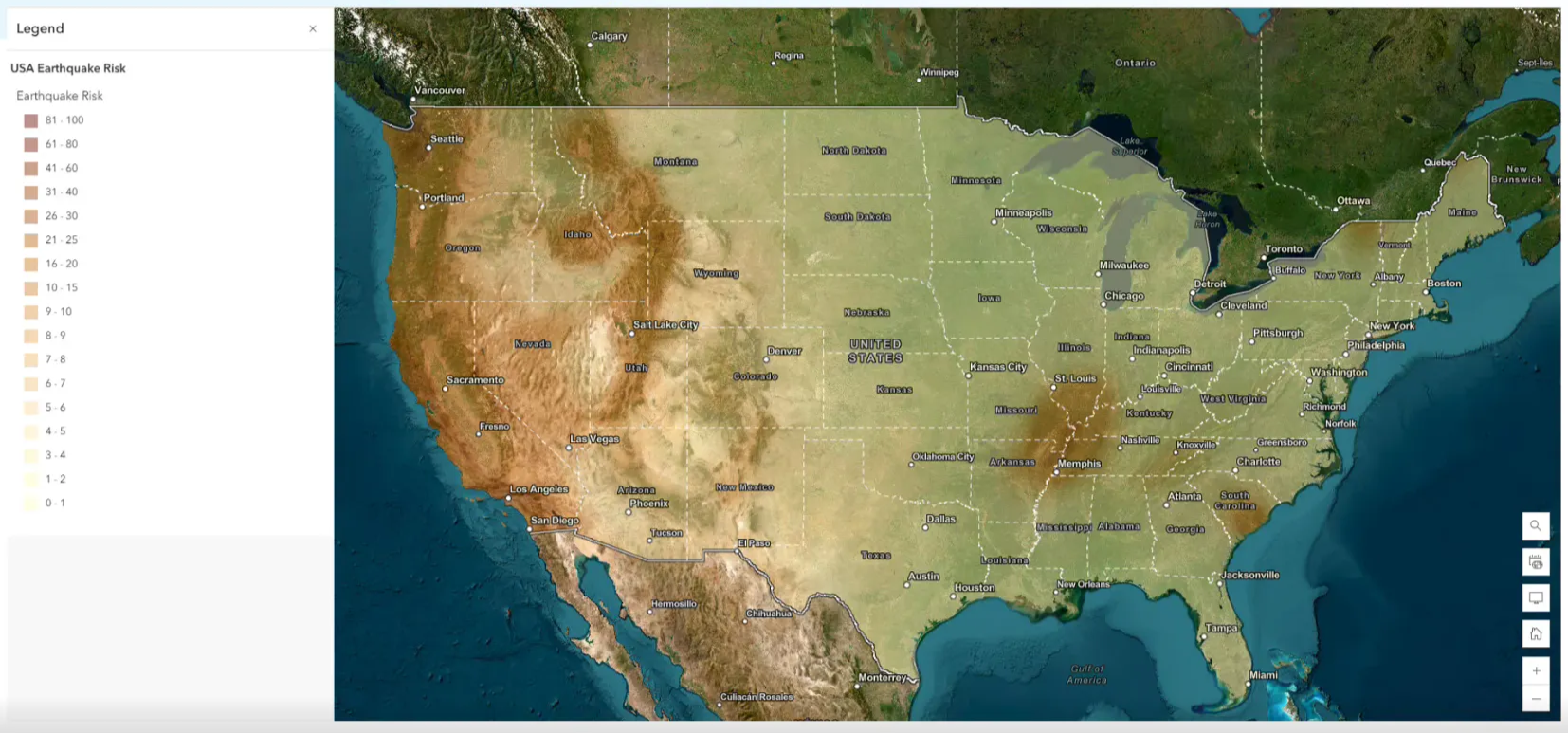
Photo Courtesy: 2025 AssetIntel™ Annual User Group meeting - ARDOT's Presentation of emergencyX™
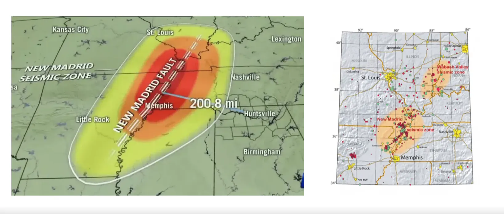
Photo Courtesy: 2025 AssetIntel™ Annual User Group meeting - ARDOT's Presentation of emergencyX™
Photo Courtesy: 2025 AssetIntel™ Annual User Group meeting - ARDOT's Presentation of emergencyX™
ARDOT faced two distinct but related emergency-response requirements:
Each hazard required a different workflow, but both demanded:
Addressing both hazards required emergency management software capable of supporting real-time response while also enabling large-scale planning and preparedness activities.
Photo Courtesy: 2025 AssetIntel™ Annual User Group meeting - ARDOT's Presentation of emergencyX™
During the April 2025 storm event, ARDOT monitored weather and hydrologic conditions statewide using:
The operational objective during the event was to ensure timely response for bridges with established Plans of Action (POAs) related to scour risk.
Early in the storm, ARDOT identified approximately 160 bridges with active POAs requiring heightened awareness. Under previous practices, monitoring flood conditions and initiating inspections relied largely on manual review of NWS alerts by districts or local owners, followed by independent field verification.
During a large, rapidly evolving storm event, this approach limited ARDOT’s ability to:
Using emergencyX™, ARDOT was able to centralize weather monitoring and alert review through a single emergency management software environment, allowing flood conditions, bridge inventory data, and POA requirements to be evaluated together. This provided a structured basis for prioritization and enabled a coordinated transition from monitoring to field deployment as conditions evolved.
As weather conditions evolved:
Approved structures were then grouped based on:
Additional groupings included:
This grouping allowed inspectors to focus on the most critical assets first while maintaining statewide awareness.
ARDOT coordinated seven field teams simultaneously, using emergencyX™ to:
Office staff monitored field activity continuously, adjusted routing to avoid flooded roads, and identified locations where inspections would need to be deferred due to access or safety constraints.
Inspections were performed in clusters based on predicted impact and accessibility, improving:
This level of coordination would not have been feasible without emergency management software designed to support dynamic assignment and real-time visibility during active events.
For each inspected structure, inspectors were required to capture:
Where access was limited, drone-assisted inspections were used.
Inspectors completed a standardized emergencyX™ inspection form, documenting:
Each data element allowed photo attachments and notes, ensuring consistency across all inspections. After fieldwork, engineers conducted post-event reviews and analysis.
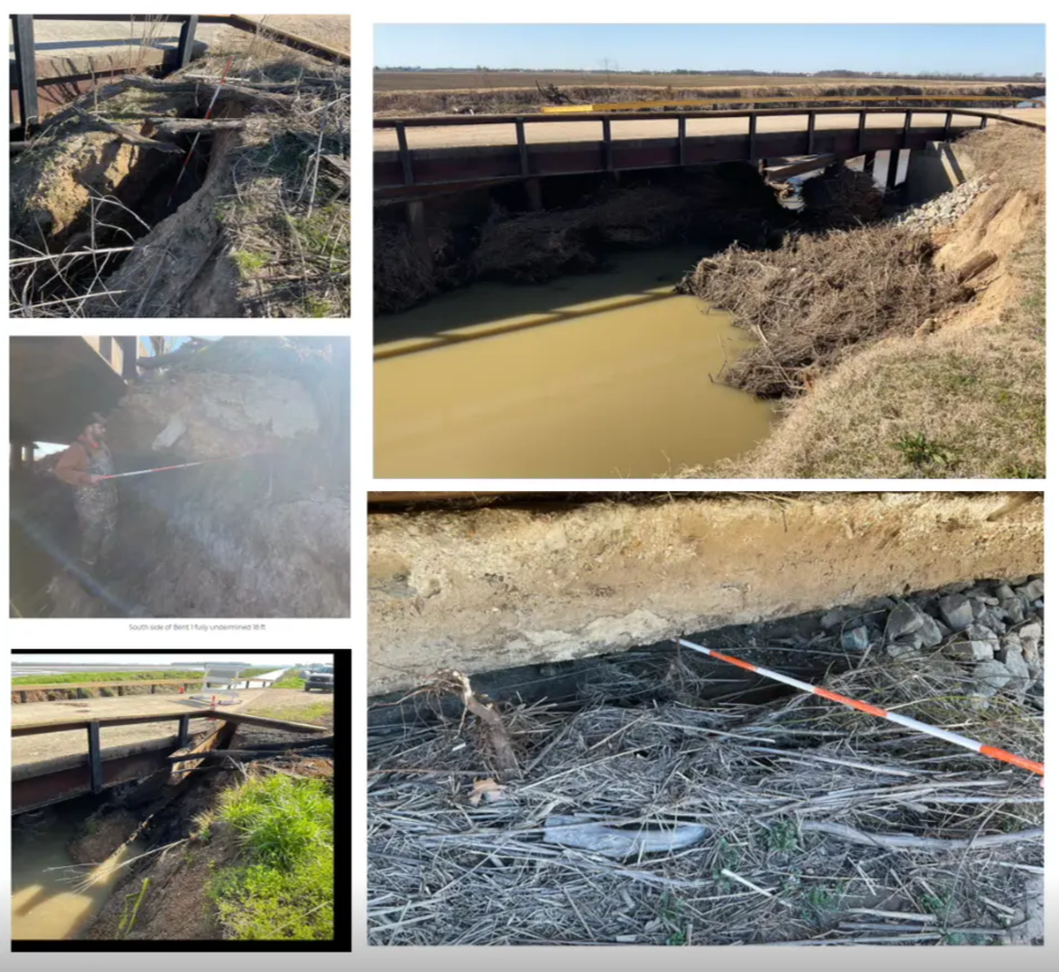
Photo Courtesy: 2025 AssetIntel™ Annual User Group meeting - ARDOT's Presentation of emergencyX™
In several cases:
Follow-up inspections revealed:
As a result, the affected bridge was closed until repairs could be completed.
In parallel with flood operations, ARDOT uses emergencyX™ as its emergency management software to support earthquake response planning in coordination with USGS ShakeCast.
ARDOT collaborates with USGS experts, including:
ShakeCast data is integrated with ARDOT’s bridge inventory to support earthquake impact modeling and inspection planning.
Two complementary modeling approaches were used:
Results included:
From the modeled impacts, ARDOT narrowed the scope to 211 bridges requiring inspection.
Key characteristics of this inspection set included:
ARDOT developed conservative inspection estimates:
Under these assumptions, ARDOT estimated:
Earthquake inspections are conducted using a modified, rapid inspection approach within emergencyX™.
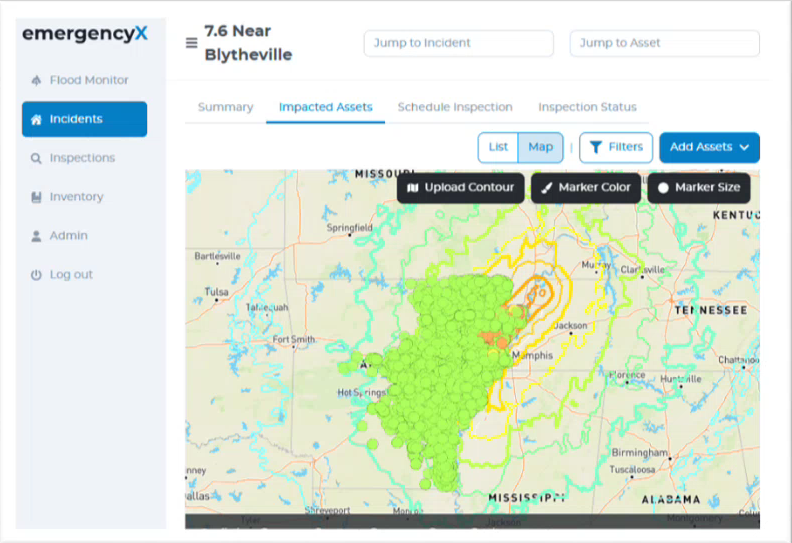
Photo Courtesy: 2025 AssetIntel™ Annual User Group meeting - ARDOT's Presentation of emergencyX™
Inspectors apply color-based safety ratings:
Inspection criteria address:
Each element supports photo attachments and notes, enabling rapid safety determinations and clear documentation.
By using emergencyX™ for both flood response and earthquake preparedness, ARDOT achieved:
The same platform supported real-world response and scenario-based planning without duplicating systems or workflows. By relying on a single emergency management software platform, ARDOT avoided fragmented workflows while maintaining consistency across both operational response and preparedness planning.
ARDOT plans to:
This case study is developed from 2025 AssetIntel™ Annual User Group meeting - ARDOT's Presentation on emergencyX™.
Ready to transform your operations? Schedule a consultation today and unlock the full potential of your asset management capabilities with our innovative solutions.